Yep, the island of Santorini in its current shape was formed around 1666 AD, and not in some ridiculous 1642–1540 BC. This is, for a second, a 3200 year difference. There was never an above water eruption of some volcano mountain they call Thera. The first thing we could do is lay to rest the idea of Santorini being the legendary Atlantis. But this one is up to you.


These days, every time I hear some historical data pertaining to thousands of years ago, something clicks, and I go in for my own research. How far back can we trust our official history. Not far in my opinion, may be not at all. We have 9/11, we have all these Middle Eastern conflicts of the recent years, we have African shenanigans of today; do you really think we know anything about the true nature of those events? I hope not. So how far back in history should we go, before we start questioning the official version? All these are purely rhetorical questions, they do not require an answer.
Governments appear to be hiding the genuine motives behind their actions. They substitute those motives with legends, designed to be consumed by the general populace. In the end, we are simply left with riddles, and puzzles here and there. Trying to solve some of them is all we have left, or so it seems.
Note: I believe that 350 years ago local people knew more on this issue than our contemporary scholars of today.

The Minoan eruption of Thera, also referred to as the Thera eruption, Santorini eruption, or Late Bronze Age eruption, was a major catastrophic volcanic eruption with a Volcanic Explosivity Index (VEI) of 6 or 7 and a dense-rock equivalent (DRE) of 60 km3 (14 cu mi), Dated to the mid-second millennium BCE (between 1642–1540 BCE), the eruption was one of the largest volcanic events on Earth in recorded history. It devastated the island of Thera (now called Santorini), including the Minoan settlement at Akrotiri and communities and agricultural areas on nearby islands and the coast of Crete with a related earthquake and tsunami.


Important: Basically, what we can get out of the official version above is this:
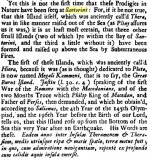
THERAThe official version tells us that before the island was named Santorini, it was known as Thera. Also in the official version, the second biggest island is called Therasia. Here we come to our first revelation. Santorini was never called Thera - this is a lie. They were not even close to each other within the scale of the Aegean Sea. Let's see what the 1687 text says.

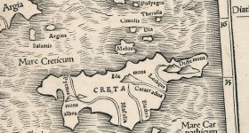
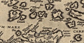
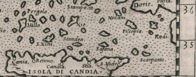
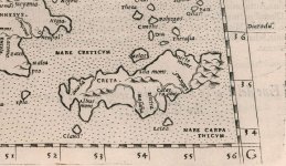
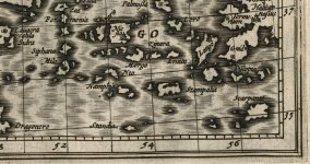
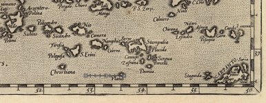
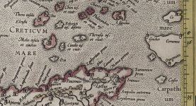
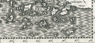
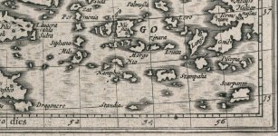
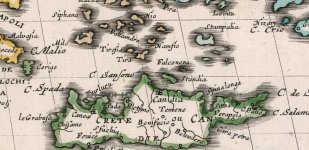
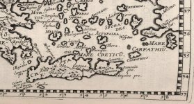
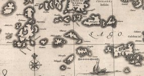
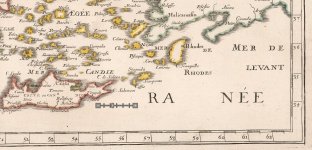
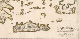
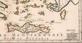
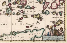
Obviously, Thera and Therasia appear to sound pretty close. We even have the second biggest island in the group called Therasia. So what's the big deal there? Well, the problem we have is this - Thera and Therasia were located in two different places. The below maps are dated 1540, 1561, 1599 and 1618.
1540

1561

1599

1618

In 1648, 1649 Thera/Tira moved south east of Therasia. Hard to say what could be the cause. Keep on reading for a possible explanation of the situation in the region.

On the above maps we can clearly see that in the 16th and 17th centuries people considered Thera and Therasia to be two different islands. Therefore Thera could never become Santorini, and only Therasia could.
A Tiny Summary:

1666 map published in 1697
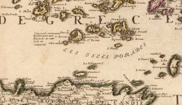
(33 years later. why?)I think the below map is an indicator of some major catastrophic event which took place in the region. Multiple islands disappeared, some came up, and others changed their shape. Our poor Therafia was either under water, or the cartographers did not really know what was out there any longer.

This next map dated 1670 brings in some clarity. It can suggest that cartographers received more data and were able to start putting information back in order.

1685 - the year of our SantoriniAnd only in 1865 the Santorini group acquires the resemblance of its contemporary looks. Simultaneously it is laughing at our today's scientists. Today we have 5 islands in the group. In 1685 there were like 11 or 12.

MAP PROGRESSION
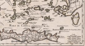
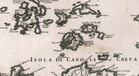
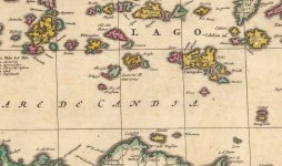
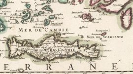
1540-1715Below you can see thumbnails of all the map cut outs I did. Some of them will overlap. Some of them will jump slightly forward in time, and some will insignificantly fall back. Some will have some unknown names listed. Simply follow the progression and follow Therasia turning into Santorini.
Did the island of Santorini rise from the sea, or was the island of Therasia destroyed by some unknown weapons? I don't know. One thing appears to be certain, there was no volcano mountain called Thera. Jumping ahead of the below text I wanted to show you a map with a yellow line showing the distance from Santorini to the island of Chios. In today's miles it is approximately 150 miles away. The author of the text claims that it was about 200 miles back then. May be miles were different, or may be our island was positioned differently. Who knows?
FYI, the 1980 eruption of Mount St. Helens could be heard from 140 miles away. Which means whatever happened on Therasia was not some minor event.

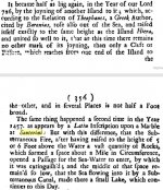
The below book was published in 1686. Count back "about" 18 years, and we end up with 1668. I will speculate here, but if we account for "about 18", and that the book had to be written before being printed... we end up very close to 1666. Remember the below map?
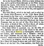
Question: what makes silver turn red, and then go back to normal color? What has to be in the air for your silver coin to turn red? Why with the dissipated element, the silver went back to normal silvery color. If it was sulfur oxide, why did the color return to normal?
While trying to get a better idea of what year "about 18 years ago" could be attributed to, I came across the below 1685 book:
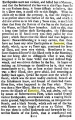
This Nea Kameni is a small island in the middle of the Santorini harbor. It was raised up from the bottom of the sea on May 23rd, 1707.
The continuation of this 1707 story is pretty interesting, though they do go into some religious Pluto related mambo-jambo, and talk about ancient Romans who probably existed just a few hundred years prior to the very same year 1712 this book was published in. This book names Santorini Thera again. It also gives some confusing account of various Santorini group islands emerging from under the sea. The reading is fascinating, because it totally contradicts anything and everything our scientists told us about this Santorini group.
Sources:
KD thoughts: We have what we have. I do not see any 3600 year old volcano there. Maps do not support the official narrative. Texts do not support the official narrative. Yet, our dogmatic scientists do everything in their power to push certain events as far back as they can to justify the period of antiquity. What are they hiding from us in the process?
P.S. And for those who want to dig into the history of Therasia aka Santorini, you can try to find some information pertaining to the following.
These days, every time I hear some historical data pertaining to thousands of years ago, something clicks, and I go in for my own research. How far back can we trust our official history. Not far in my opinion, may be not at all. We have 9/11, we have all these Middle Eastern conflicts of the recent years, we have African shenanigans of today; do you really think we know anything about the true nature of those events? I hope not. So how far back in history should we go, before we start questioning the official version? All these are purely rhetorical questions, they do not require an answer.
Governments appear to be hiding the genuine motives behind their actions. They substitute those motives with legends, designed to be consumed by the general populace. In the end, we are simply left with riddles, and puzzles here and there. Trying to solve some of them is all we have left, or so it seems.
Note: I believe that 350 years ago local people knew more on this issue than our contemporary scholars of today.
SANTORINI
(the official version)
Santorini, classically Thera, and officially Thira, is an island in the southern Aegean Sea, about 200 km (120 mi) southeast of Greece's mainland. It is the largest island of a small, circular archipelago, which bears the same name and is the remnant of a volcanic caldera. The municipality of Santorini includes the inhabited islands of Santorini and Therasia and the uninhabited islands of Nea Kameni, Palaia Kameni, Aspronisi, and Christiana (way out south-west).(the official version)
Important: Basically, what we can get out of the official version above is this:
- There used to be a single island called Thera/Thira.
- Minoan eruption took place between 1642–1540 BCE. That is roughly 3600 years ago.
- Current Santorini group has 5 islands: Santorini, Therasia, Nea Kameni, Palaia Kameni, Aspronisi, and Christiana.
THERA
1540
1561
1599
1618
1648

1649

In 1650 Thera is moved back north-west of Therasia. It's a fun ride with those older maps. Dating is obviously hard, and there could be quite a few fakes along the way.1649
A Tiny Summary:
- 1687 text stated that the ancient name of Santorini was Therasia
- various maps place Thera ways away from Therasia
- Thera is neither Therasia nor Santorini
- Thera and Milos appear to be one and the same
MILOS
Milos is approximately 50 miles away from Santorini. The island of Milos, or Milo, or Melos has nothing to do with Santorini. I wanted to use it as an example. It shows that people in 1608 could properly depict the shape of an island in accordance with its appearance. In other words if there is a big hole in the island, they knew how to depict it on a map. As you navigate through the below presented maps, please keep in mind this island of Milos, as a good reference to the location of Therasia.1608 - 2018


THERASIA
At some point the island of Therasia became our Santorini. Via the map analysis this date could be estimated as 1655.THERASIA
1666 map published in 1697
(33 years later. why?)
This next map dated 1670 brings in some clarity. It can suggest that cartographers received more data and were able to start putting information back in order.
1685 - the year of our Santorini
MAP PROGRESSION
1540-1715
Did the island of Santorini rise from the sea, or was the island of Therasia destroyed by some unknown weapons? I don't know. One thing appears to be certain, there was no volcano mountain called Thera. Jumping ahead of the below text I wanted to show you a map with a yellow line showing the distance from Santorini to the island of Chios. In today's miles it is approximately 150 miles away. The author of the text claims that it was about 200 miles back then. May be miles were different, or may be our island was positioned differently. Who knows?
FYI, the 1980 eruption of Mount St. Helens could be heard from 140 miles away. Which means whatever happened on Therasia was not some minor event.
Question: what makes silver turn red, and then go back to normal color? What has to be in the air for your silver coin to turn red? Why with the dissipated element, the silver went back to normal silvery color. If it was sulfur oxide, why did the color return to normal?
While trying to get a better idea of what year "about 18 years ago" could be attributed to, I came across the below 1685 book:
1685

Both of the above excerpts appear to be talking about the exact same event. Only the 1685 one, gives us an idea of when the above described events took place. We had the following people in power:
KD: Essentially, we have this peculiar situation, where our Santorini acquires its shape on the maps circa 1666 AD, and texts suggest that the event took place circa 726 AD.- 726 AD is fully supported by the narrative, but this date is not supported by the above map progression. It appears that the island of Santorini follows a dating pattern similar to the one described in the below three articles.
St. Erine
As was mentioned above, based on the older maps, the first time we see Therasia turn into Santorini was in (circa) 1655. Per wikipedia, Santorini was named by the Latin Empire in the thirteenth century, and is a reference to Saint Irene.- Latin Empire (1204 AD -1261 AD)
- Saint Irene (Died: 304 AD)
- Sure makes a lot of sense to rename the island of Therasia to Santorini 950 years after the lady died.
Nea Kameni Island
(New Rocks Island)

(New Rocks Island)
This Nea Kameni is a small island in the middle of the Santorini harbor. It was raised up from the bottom of the sea on May 23rd, 1707.
- But... everything is covered: Santorini Volcano Kameni Islands Evolution
1712 Book

The continuation of this 1707 story is pretty interesting, though they do go into some religious Pluto related mambo-jambo, and talk about ancient Romans who probably existed just a few hundred years prior to the very same year 1712 this book was published in. This book names Santorini Thera again. It also gives some confusing account of various Santorini group islands emerging from under the sea. The reading is fascinating, because it totally contradicts anything and everything our scientists told us about this Santorini group.
Sources:
- 1687 - The Travels Of Monsieur De Thevenot Into The Levant
- 1712 - Philosophical Transactions
- 1685 - In Institution of General History, Or The History of the World
- Maps
KD thoughts: We have what we have. I do not see any 3600 year old volcano there. Maps do not support the official narrative. Texts do not support the official narrative. Yet, our dogmatic scientists do everything in their power to push certain events as far back as they can to justify the period of antiquity. What are they hiding from us in the process?
- If there is any merit to the above observations, the entire timeline of the 4500 year old Minoan Civilization could be highly questionable.
- Pretty sure my "scratch the surface" living room investigation left a lot to be uncovered, but I think it could be a good place to start for those looking for honest answers.
- What do you think about all this?
P.S. And for those who want to dig into the history of Therasia aka Santorini, you can try to find some information pertaining to the following.
Town: Famosa or Samosa
I am not sure whether its "F" or an "S." It sure does look like an "F" but with these older texts you never know. Anyways, there you go:- Do we have any additional info on this town?
- What marble chests with lids are being talked about?
- Do we have any images of the large statues mentioned in the excerpt?


