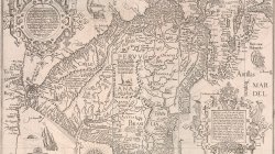
An extraordinary map of South America, the Caribbean islands, and Florida, shown on a horizontal axis. This is one of the most striking and decorative maps of South America and is an important early record of the continent. The map is oriented with north to the right and includes Florida and the Gulf Coast (over 20 place names shown), and the Caribbean. The Straits of Magellan are depicted, with Terra del Fuego shown as a part of the great southern land mass. The coastlines are well defined and densely engraved with place names while the interior is filled with fictional mountains, rivers and vignettes of Patagonian giants, Brazilian cannibals and numerous strange animals including a lion-like creature with a striped tail and human face. Other embellishments include large elaborate cartouches, sea monsters, galleons and a beautiful compass rose.