
carta marina
-
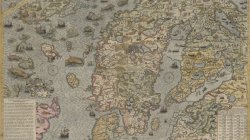
Carta Marina by Olaus Magnus published by Antony Lafreri in 1572
The Carta marina of the Swedish geographer and historian Olaus Magnus is one of the earliest accurate cartographic depictions of the Scandinavian peninsula. Drafted in Rome in 1539, by one of the more prominent Scandinavian Catholics in higher ecclesiastical service, it contains detail that is...- KorbenDallas
- Media item
- antony lafreri carta marina map olaus magnus
- Comments: 0
- Category: Europe
-
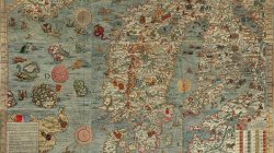
1527-39 Carta Marina by Olaus Magnus
Carta marina et descriptio septentrionalium terrarum is the first map of the Nordic countries to give details and place names, created by Swedish ecclesiastic Olaus Magnus and initially published in 1539. The map was created in Rome during 1527–39 by Olaus Magnus. To construct the map...- KorbenDallas
- Media item
- carta marina map olaus magnus
- Comments: 0
- Category: Europe
-

1530s Iceland: Reykjahlíð vs. Saxa and Scalholdin. Vanished cities?
This article was originally published on 2/2/2019. While looking for the origins of Saint Patersburg, I came across this 1539 map called Carta Marina. After zooming in on Iceland, and googling some of the cities, I ran into another map called Da Islandia Insula, and attributed to 1566. Below...- KorbenDallas
- Article
- carta marina iceland scalholdin
- Replies: 0
- Section: Europe