Area 51 a.k.a. Totonteac: the Seventh City of Cibola?

The hypothesis pertaining to the notorious and secretive Area 51 will have nothing to do with aliens, or UFOs. On the other hand it will have everything to do with the previous spin of our civilization, old maps and legendary cities of the past.

area51-sign.jpg

This is not something we will ever be able to verify, but I figured a different Area 51 related hypothesis would not hurt. At first let us get some basic info on Area 51.

Area 51
The United States Air Force facility commonly known as Area 51 is a highly classified remote detachment of Edwards Air Force Base, within the Nevada Test and Training Range. According to the CIA, the correct names for the facility are Homey Airport and Groom Lake, though the name Area 51 was used in a CIA document from the Vietnam War. The facility has also been referred to as Dreamland and Paradise Ranch, among other nicknames. USAF public relations has referred to the facility as "an operating location near Groom Dry Lake".
  • General Info:
    • Coordinates - 37°14′06″N : 115°48′40″W
    • The base's current primary purpose is publicly unknown.
    • The intense secrecy surrounding the base has made it the frequent subject of conspiracy theories and a central component to the UFO folklore.
    • Although the base has never been declared a secret base, all research and occurrences in Area 51 are Top Secret/Sensitive Compartmented Information.
    • On 25 June 2013, following a Freedom of Information Act request filed in 2005, the CIA publicly acknowledged the existence of the base for the first time, declassifying documents detailing the history and purpose of Area 51.
  • History:
    • Lead and silver were discovered in the southern part of the Groom Range in 1864.
    • The English Groome Lead Mines Limited company financed the Conception Mines in the 1870s, giving the district its name.
    • The interests in Groom were acquired by J. B. Osborne and partners and patented in 1876, and his son acquired the interests in the 1890s. Claims were incorporated as two 1916 companies with mining continuing until 1918 and resuming after World War II until the early 1950s.
    • The airfield on the Groom Lake site began service in 1942 as Indian Springs Air Force Auxiliary Field, and consisted of two unpaved 5000-foot runways.
    • The Groom Lake test facility was established in April 1955 by the CIA for Project AQUATONE, the development of the Lockheed U-2 strategic reconnaissance aircraft.
Historical Maps
It is important to understand that the North American continent went through some serious geological transformations. Our today's pseudo-scientists branded older maps as a sick fantasy of the poorly uneducated cartographers of the past. We are to believe that such esteemed scholars like Mercator (1512-1594), and Ortelius (1527-1598) were dumb and stupid enough to depict something they knew was not there.

Around 1650s the North American Continent suffered the same fate the rest of the world did. To reference what I'm talking about use these links:
Anyways, the North American Continent went through the following major stages. The below compilation is an approximate transformation progression. For more details please visit this link. There could have been an additional stage, but that one is much harder to work with.

american_transformation.jpg

Sometime around 1650s, an event of great magnitude took place. This event drastically changed the outline of the Pacific North West area of the North America. Whether the area was entirely, or partially flooded, but the outline of the Continent did change. Some of the known coastal areas vanished with no trace.

1630_Nova_totius.jpg

Source

The Seven Cities of Cibola
The Seven Cities of Gold, also known as the Seven Cities of Cibola, is a myth that was popular in the 16th century. It is also featured in several works of popular culture. According to legend, the seven cities of gold could be found throughout the pueblos of the New Mexico Territory. The cities were Hawikuh, Halona, Matsaki, Quivira, Kiakima, Cibola, and Kwakina. While there have always been mentions of a seventh city, no evidence of a site has been found.
  • In the 16th century, the Spaniards in New Spain (now Mexico) began to hear rumors of "Seven Cities of Gold" called "Cíbola" located across the desert, hundreds of miles to the north. The stories may have their root in an earlier Portuguese legend about seven cities founded on the island of Antillia by a Catholic expedition in the 8th century, or one based on the capture of Mérida, Spain by the Moors in 1150.
  • The later Spanish tales were largely caused by reports given by the four shipwrecked survivors of the failed Narváez expedition, which included Álvar Núñez Cabeza de Vaca and a black moorish slave named Esteban Dorantes, or Estevanico. Eventually returning to New Spain, the adventurers said they had heard stories from natives about cities with great and limitless riches. However, when conquistador Francisco Vázquez de Coronado finally arrived at Cíbola in 1540, he discovered that the stories were unfounded and that there were, in fact, no treasures as the friar had described - only adobe towns.
  • While among the towns, Coronado heard an additional rumor from a native he called "the Turk" that there was a city with plenty of gold called Quivira located on the other side of the great plains. However, when at last he reached this place (variously conjectured to be in modern Kansas, Nebraska or Missouri), he found little more than straw-thatched villages.
Cibola-the-Seven-Cities-of-Gold.jpg

In 1539, Friar Marcos de Niza, a Franciscan priest, reported to Spanish colonial officials in Mexico City that he’d seen the legendary city of Cibola in what is now New Mexico. It was an electrifying statement - Spanish explorers who were scouring the New World for Native American treasure had heard persistent tales of the fantastic wealth of the so-called Seven Cities of Cibola.
  • “It is situated on a level stretch on the brow of a roundish hill,” the friar said. “It appears to be a very beautiful city, the best that I have seen in these parts.” The priest acknowledged, however, that he had only seen the city from a distance and had not entered it because he thought the Zuni Indian inhabitants would kill him if he approached.
  • But when a large and expensive Spanish expedition returned to the area in 1541, they found only a modest adobe pueblo that wasn’t anything resembling what the priest described. The expedition turned out to be a ruinous misadventure for those involved - including famed conquistador Francisco Vazquez de Coronado, who led it.
  • “Virtually everyone, including the leader, returned to Mexico City heavily in debt,” says New Mexico author Richard Flint, who, with his wife, Shirley Cushing Flint, has written five books about Coronado. “A number of those people never recovered financially.”
  • For five centuries, scholars have debated what de Niza saw when he claimed he’d found Cibola - or whether he simply told Spanish officials what they wanted to hear.
  • The Seven Cities of Cibola
Additional links:
KD: I have an issue with the Coronado expedition narrative. His route does not match the location of the Quivira Regnum presented on the older maps. There is a pertaining article here on SH. Due to this fact I have a fairly strong believe that either the records were altered, or the documents were outright fabricated to demonstrate that there was nothing of significance in the explored area. Coronado's expedition provided us with one additional detail which I plan on covering in the nearest future.
  • If you can find a life time depiction of Francisco Vázquez de Coronado, please share. I have my doubts about this gentleman, for there are too many historical fact which entirely depend on the literary results of his expedition.
Area 51 a.k.a. Totonteac
While there have always been mentions of a seventh city, no evidence of a site has been found. To be honest, I am not sure of what evidence of the first six cities they found. If anything, the narrative went out of their way to convince everybody that these cities never existed in the described state. Calculating the exact location of Totonteac, we should probably consider the Expanding Earth hypothesis in mind.


I think this seventh missing city was Totonteac, and it was buried/destroyed in the event of the 1650s. I also think that our Area 51 is located directly over the top of this buried city. I understand that it is much easier to attribute all the secrecy to the UFO reverse engineering, but it appears that we could have our earthly things to reverse engineer.
  • To be honest, I do not know how the count the cities, for we do appear to have seven. May be Cibola itself does not count as one.​
    • Hawikuh, Halona, Matsaki, Quivira, Kiakima, Cibola, and Kwakina.
Totonteac and Cibola
I have seen four various English language spellings of this city: Tonteac, Tototeac, Totonteac and Tontonteac. The actual city appears to have been a part of the Totonteac Regnum. Well, let us see what the older books have to offer in reference to our Totonteac and the Seven Cities of Cibola.

In 1714, approximately 75 years after the area cities got destroyed, the following was published. Interesting that a lake was mentioned. Could it be our Groom Lake?

tontonteac4.jpg

But it's texts like the 1628 one below, which have nothing to do with our Totonteac, but have the location mentioned due to the author's associations, that make me believe that Totonteac did exist.

tontonteac.jpg

Or like this 1664 text written in the language I do not know, yet the mere inclusion of Totonteac in this list gives its existence a certain credibility.

tontonteac3.jpg

Or like these grid coordinates mentioned in 1677.

tontonteac5.jpg

It sounds like our Totonteac had better constructed buildings as compared to Cibola.

tontonteac1.jpg

tontonteac2.jpg

And here is what the city of Cibola was described as.

cibola_1.jpg


Timing
Unfortunately we cannot be sure of what happened when exactly. As long as narrative adjusters keep on providing us with bloopers like the one below, timing will always be a hard thing to figure out:
1652 Nova Totius Terrarum Orbis geographica ac hydrographica tabula_1_1.jpg


I am not going to copy/paste all the information available in the older books. Please help yourself using the below links. Click on the time span at the bottom of the linked pages and read for yourself.
Great article:
Obviously, the official narrative has everything verified, and no such cities ever existed in the described state. Yet:
  • And of course, California and Nevada are full of various National Parks, Military Installations and various other "off limits" areas.​


KD: Well, I just figured I will throw this hypothesis out there:
  • Area 51 was established to explore intellectual efforts of the previous spin of our civilization.
  • Area 51 is located on top of a buried city, which could possibly be Totonteac.
 
There is as you say a lot more hypothesis aside from the obvious are aware, did you mention White Sands or the Wingmakers just a thought!
 
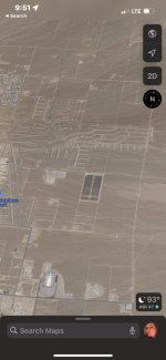
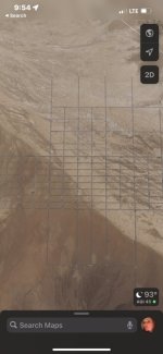
How fascinating that there are tales of ancient now vanished cities, particularly one in the region of Area 51. I have recently learned that Area 51, Edwards AFB, and the nearby town of Pahrump, Nevada were built right over the top of existing grids etched into the desert ground, which are VERY visible from above, despite the great efforts to build up as much infrastructure as they could along the grid lines in an effort to disguise them as regular paved roads and the regular layout of Pahrump, and the nearby airfields and government installations.

Here are just a couple screenshots I took, using Google Earth of all things. These are the areas surrounding Pahrump that they haven’t been able to build over yet. Notice how gray lines are actually artificially painted over the grid in the second image in a poor effort to disguise the ruins from aerial view. When you zoom all the way in, the gray lines vanish and you can see the “streets” are not paved. Trying the same thing with Bing Satellite view, the area is far more obstructed, blurred, and I was unable to zoom in very far.

5EE195CC-9A57-46DF-8B43-D5D695429384.jpeg EED1E84A-A3DB-4E38-9BB4-D72679FB24D9.jpeg

So here is irrefutable evidence that something grand once stood here where there is now just a desert waste, consistent with the accounts KD posted. I encourage everyone to hop on to Google Satellite view and explore this area, the images I have posted are only a small representation of that huge amounts of etched grids and shapes that can be seen.
 
Indeed there is some fascinating stuff in the wastelands:

51724E6F-347B-491C-BBD2-BF3C0E9C710C.jpeg

B75EDA52-9C71-4BAD-B00D-CCC87CA49763.jpeg


DA42D739-FBB3-499D-8F37-72BA9B0219B8.jpeg

the above two triangles I found in Colorado. After doing a google image search, apparently there’s a popular pair also in Arizona:

57BD5C5F-AEC1-484A-9A95-1F86C73404A5.jpeg

the ones in CO are about 20% larger and 200% further apart. AZ is ~4,000ft per side and CO is 1.05mi per side. AZ is 12.6mi apart and CO is 6.3mi apart. They also do not share congruent orientation. The lower triangle in AZ looks to have been repurposed into an airstrip, which was among my original thoughts, but why equilateral triangles, in pairs?
 
Last edited:
Suuuuper strange. I’ve been playing around feeding anti-narrative, esoteric, and other terms into AI image generators. I entered simply “cibola” into one and got this image:

1663121629529.jpg

in a desert (unprovoked) and… seven (unprovoked) connected entities.
 
How fascinating that there are tales of ancient now vanished cities, particularly one in the region of Area 51. I have recently learned that Area 51, Edwards AFB, and the nearby town of Pahrump, Nevada were built right over the top of existing grids etched into the desert ground, which are VERY visible from above, despite the great efforts to build up as much infrastructure as they could along the grid lines in an effort to disguise them as regular paved roads and the regular layout of Pahrump, and the nearby airfields and government installations.

Here are just a couple screenshots I took, using Google Earth of all things. These are the areas surrounding Pahrump that they haven’t been able to build over yet. Notice how gray lines are actually artificially painted over the grid in the second image in a poor effort to disguise the ruins from aerial view. When you zoom all the way in, the gray lines vanish and you can see the “streets” are not paved. Trying the same thing with Bing Satellite view, the area is far more obstructed, blurred, and I was unable to zoom in very far.


So here is irrefutable evidence that something grand once stood here where there is now just a desert waste, consistent with the accounts KD posted. I encourage everyone to hop on to Google Satellite view and explore this area, the images I have posted are only a small representation of that huge amounts of etched grids and shapes that can be seen.
California City is a definite second location for ruins of a former civilization- there’s much more here than we found in Pahrump! And the connection to Area 51/Edwards AFB is mentioned by the “officials” at californiacity-ca.gov, which states:

“California City is a city located in northern Antelope Valley in Kern County, California, United States. It is 100 miles north of the city of Los Angeles, and the population was 14,120 at the 2010 census. Covering 203.63 square miles, California City has the third-largest land area of any city in the state of California, and is the largest city by land area in California that is not a county seat. Much of the workforce of Edwards Air Force Base, which is located 18 miles southeast of the city, is made up of city residents.”

30563CC0-50E8-4178-A1DB-BC6833018211.jpeg


A0F0DE28-0F22-415A-81A5-11447060AF05.jpeg


081A7709-6A1D-47DF-A503-8293E0DFBBE8.jpeg

A city (more like town!) of 14,000 people is 204 square miles in size? How peculiar. Even more peculiar is the view from above. Part of me wants to throttle the Ministry of Truth over at Google for painting artificial asphalt on our grids, but another part of me wants to thank them because it does make the fainter and more isolated designs easier to spot. So considering the close proximity to Pahrump (18 miles), this was likely all part of the same vast complex.

Then, about 325 miles south, we have “Salton City” California, where the grids get even crazier.

503B6B4A-BA75-4C5C-A3A8-BD2784487D67.jpeg

Are we looking at the remnants of block design for urban areas from one of the lost cities of Cibola? Something older? What could have vaporized such large cities and turned the land into a wasteland like this?

Hey, look! Not much asphalt in Salton City at all:

DC827CCD-665E-4B38-A425-F93096C9ED48.jpeg

Hmm, let’s just zoom in a tad closer- and whoa, it’s like magic! So much asphalt!

3E453352-2593-4D16-BF9A-05721D2DDAA2.jpeg

Such a large and sophisticated city layout for a small smattering of buildings!

C930DD32-C19A-4767-B23C-CC86BDD43C24.jpeg

Near Salton City we have towns called “Mecca” and “Cathedral City” as well as the “Salton Sea” and of course, a National Park… I’d bet the farm something significant is buried under that Salton Sea. To round it off, I see “Coachella” labeled right there as well.

(The red blob to the top right of the Sea is the location of the grids I found, though there are surely many more in the area.)

9F4B270D-BBFE-443C-97DC-D3D3FEE96C5B.jpeg
 
Last edited:
I've posted about this before, and it's a little silly, but in the "Ice Age" animated short, "Scratlantis", it shows an Atlantis like world, with acorns standing in for gold. Whrn the realm is destroyed by the rodent's greed, the island paradise isflooded and buried. The location? Area 51/Totonteac area.


FEC7BDDF-6A9A-40E8-8B68-ECA9CCA158BE.jpeg


F1C13DC4-31D2-4611-88C6-3B79C4637391.jpeg


00073EBD-4B48-476A-93A8-B8CBDCEE9B84.jpeg

A8EB78DA-3CFF-4267-B6CA-EE5ECE3F511C.jpeg
 
Last edited:
@Investigator really neat find! I took Salton city and ventured north into Death Valley, and found some more:

8DEE6B9A-A462-4D52-94CC-CA32F03BA419.jpeg

8070CA5D-8274-46B9-A7BC-B915232388C7.jpeg

I’m reminded of the African deserts… perhaps a once thriving city and ecosystem turned into sand and glass.

but the real winner I found is this:

C166646B-3FE2-47EF-A37A-40FD0AF6FCC1.jpeg
I’ve never seen burning man from above, but that seems illogical to be built as such

I left the coordinates in place for your viewing pleasure.

I found another desert triangle in CO, 23mi west of the first pair:

B9D2F5AE-9CC8-4470-86AC-F4C71C938484.jpeg

This one has a very interesting composition:

DC1D6452-6EE4-4709-ADAC-6A8B3E367F9A.jpeg


and then whatever this is:
9D855FE0-DA8C-44B3-A54F-9316CED54890.jpeg
 
Last edited:
@Investigator really neat find! I took Salton city and ventured north into Death Valley, and found some more:
View attachment 12889
View attachment 12891

I’m reminded of the African deserts… perhaps a once thriving city and ecosystem turned into sand and glass.

but the real winner I found is this:

View attachment 12892
I’ve never seen burning man from above, but that seems illogical to be built as such

I left the coordinates in place for your viewing pleasure.
How is it that these grids are ALL OVER the wastes and they’re completely unacknowledged? The way that TPTB have built right over them, stealing the pre-existing layouts for our “modern” towns is literal stolen history unfolding before our eyes in real time.

I find it interesting that the major and minor highways go through these grid areas as well, highly indicative that the highway systems were also pre-existing. (which we already knew, but still great to gather more evidence). I’m finding the most of these desert etchings by following along the highways and checking the surrounding areas.

I was unaware of the lost cities of Cibola before this thread and I really think we’ve found parts of some of their corpses displayed as these grids.

@reverendALC did you lose hours of your day obsessively scanning the wastelands? I couldn’t believe how much time flew by while I was grid-hunting. That semicircle formation you found is insane- but I didn’t quite understand, that’s the location of BM? Are they actually holding Burning Man right on top of a particularly complex grid ruin?? Unreal. Yet somehow not surprising. Strange how you mentioned the African wastes, because I found some disturbing etchings in and around Mogadishu. I was thinking of finding an appropriate topic to post those findings in.

Back to our lost cities… I just had the thought that there are surely vast underground tunnel systems in the vicinity of Pahrump, CA City and Salton City as well. We already know there are huge (alleged) subterranean systems in Death Valley. Any other implications of these findings?

I don’t know if anyone else here is a Gen X-er like me who grew up listening to Coast to Coast with Art Bell. If I recall, Art lived in Pahrump and used that as a gimmick: “Live from right outside Area 51!” I wonder, for a “reporter” who was the leading voice on the paranormal and conspiracy theory, he never mentioned the fact that he lived on top of an ancient ruin. Could it be he didn’t know? That seems doubtful… I’m starting to think he was part of Operation Mockingbird all along. Anyways. I’ll stop making connections regarding these grids now, there are just too many possibilities!
 
@Investigator I've known of burning man, but never went or cared much. I found that pattern, ran it through google lens, and discovered that is where burning man is held. the grid there is a feat of engineering I would assume far beyond the reach of those involved in the drug/sex/music fest that is burning man. scanning these wastelands is reminiscent of the richat structure.

EDIT: I found another matching pair of triangles in arizona

8852E0D4-8B18-48DF-BA76-9EBD151512B3.jpeg

They’re the same size as the other AZ pair.
 
Last edited:
Just to riff a little longer on California City and the dubbed “geoglyphs” there… apparently there’s an explanation. According to Wikipedia, California city was paved by a land developer who planned on making a city to rival Los Angeles. Embroiled in scandal and fraud, that didn’t pan out apparently.

it’s quite the tale, and I’m having trouble drawing up much to corroborate it in terms of the actual creation of the roadways… but the article cites something else interesting and possibly for another topic:

“The Italian-American civil engineer Olindo R. Angelillo surveyed the city's aquifer on behalf of CCDC in 1959, stating it was on top of a "virtual underground lake" of 1 million acre-feet of water per year.”

@Investigator you know what I’m talking about.

********NEW INFO********

I’m not sure if any of this is related to the cities of cibola, or if this is meandering off topic… but digging deeper into the subterfuge related to California city… it’s really a lot of he said she said. The same exact words are repeated on every blog, newspaper, or other media I can find mentioning it. Like, verbatim. Copy&paste.

I did find an article researching the man behind the California city story/plan, and learned that he sold the business in 1972 to another company, and this other company was also implicated in “city building scams” including Colorado City, CO and Cochiti Lake, NM.

A338B71D-4A87-49F5-9F07-2D0146288FD5.jpeg


00117B24-2EEE-4C80-9DE0-C00D86B34ABB.jpeg

Now this article, the most fruitful thing I’ve discovered, seems to me to be mostly ‘splaining away the “ghost grids” with these stories and attempting to remove any sense of mystery or wonder. As I struggled through this read, and I’m glad I did, I found this (emphasis added by me):

“Smith & Williams, a south Pasadena architecture firm, was hired to create the overall visual concept for this master-planned community that emphasized a modern, social-oriented design. Mendelsohn ambitiously proposed seven “satellite cities” with 30,000 people in each area plus a centralized city of 85,000 residents[8] that would soon eclipse Los Angeles’ monumental sprawl in size and population.”

Back to my previous post, an AI interpretation of “cibola” depicted as:

1663986854436.jpeg

it sure resembles a mega city with seven satellites.

so far, and without any degree of certainty, Smith&Williams has been attributed:
California city we’ve covered.
Newport dunes… that’s an interesting one. It’s completely and totally densely populated. This first picture is random California urban sprawl:

4C418F4A-C814-43E0-9A9C-E306BC279DCF.jpeg

this is Newport dunes area:

2C97E4B8-D8A2-48CF-B216-451619AE225B.jpeg

perhaps some of these cities are still cities? Or are under cities?

there is some great old media regarding Smith&Williams’ proposed “works” here

I have taken the liberty of creating a google map. I think it’s publicly available, please let me know if it’s not.
 
Last edited:
Indeed interesting, but they seem decidedly different to me. The grids are insanely accurate and precise, mathematical and geographical accomplishments of enormous scale.

while those are also at a respectable scale, they resemble the doodles of small children to me. I wouldn’t imagine somebody creating those being capable of the grids, and similarly somebody capable of the grids stooping to such imprecise designs.

side note, I appended my previous post significantly, it’s worth reviewing if you’re interested in this thread!

ive located a very large, very intricate grid in El Paso:
7F9232C7-9CD1-4AFD-8FD0-C2215233AF62.jpeg


here are grid (and triangle) placements thus far:
E0E12693-DD21-4C00-BA3C-6027CAED9636.jpeg


@Recognition here is my collection of grid cities and triangles, next to the scratlantis deluge:
DDE2FCEC-E016-4E11-9BF9-DE050BE70BBF.jpeg


and here's an overlay:
1664483366406.jpg


at the very least, an amazing coincidence
 
Last edited:
exploring Utah, central to all of the grids and geoglyphs plotted… the earth is inhospitable. There’s literally nothing resembling life or civilization, but there are some interesting geographical conditions.

it sort of looks like everything melted:
1664507854562.jpeg


and then I found this place:
1664507552441.jpeg


this is lava according to geologists, but I’ve never seen lava like this
 
exploring Utah, central to all of the grids and geoglyphs plotted… the earth is inhospitable. There’s literally nothing resembling life or civilization, but there are some interesting geographical conditions.

it sort of looks like everything melted:
View attachment 12961

and then I found this place:
View attachment 12960

this is lava according to geologists, but I’ve never seen lava like this
Looks as if old structures were melted by???
 
If there was a great civilization there, and there was some grand elimination event… perhaps some enormous bomb turned the Midwest into the barren wasteland that it is?

the melted rocks are ground zero here:
1664548279031.jpg

Pahvant Butte. It’s a dormant volcano, which suspiciously resembles a blast crater. Then there’s this weird abandoned structure on one of the crater (I mean volcano) crests:
1664548651838.jpg

Along the southeast rim of the inner depression of the volcano is an unfinished structure consisting of a concrete building embedded in the hill surrounded by two rings of concrete obelisks. The structure was apparently began by a man named A. H. Hood, with the intention of generating wind power, in 1923.

that’s from Wikipedia, but alas the two citations are flimsy and the one that actually mentions the structure admits to regurgitating unverifiable rumors.
 
Last edited:
If there was a great civilization there, and there was some grand elimination event… perhaps some enormous bomb turned the Midwest into the barren wasteland that it is?

the melted rocks are ground zero here:
View attachment 12962
Pahvant Butte. It’s a dormant volcano, which suspiciously resembles a blast crater. Then there’s this weird abandoned structure on one of the crater (I mean volcano) crests:
View attachment 12963
Along the southeast rim of the inner depression of the volcano is an unfinished structure consisting of a concrete building embedded in the hill surrounded by two rings of concrete obelisks. The structure was apparently began by a man named A. H. Hood, with the intention of generating wind power, in 1923.

that’s from Wikipedia, but alas the two citations are flimsy and the one that actually mentions the structure admits to regurgitating unverifiable rumors.
Go back to KDs old site about 2018 where we talked about Oklahoma being the most important place on earth according to the Smithsonian institute own words.
I sent in a page from the Oklahoma historical society stating that they were the only organization in the world that had a professional relationship with the Smithsonian.
Or something along those lines.
A lot of questions arose from those comments by the Smithsonian.
 
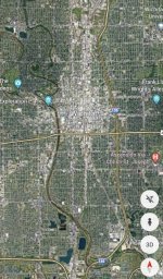
There’s an interesting tangent here… something I posited during my previous rant about Newport Dunes. After staring at grid cities for countless lengths of time, you start to recognize congruent/similar patterning. They’re like snowflakes, no two alike, however they’ve got recurring themes and common design elements.

There are two metropolises in OK; . Here are some grid views of them, in respective order:
F72F1FB8-E8FB-49C1-8DE8-F16852034CFA.jpeg


B616D6F5-0A85-4CE6-93AD-B49927F53BE2.jpeg


there are definitely the whimsical design elements of the barren grids present.

here are some grid views of Kansas City, St Louis, and Wichita, the nearest (northerly/easterly) metropolises.

D4D9908B-7FC9-44E8-B4A8-4EA1EA142FD3.jpeg


2F0E2E1E-001D-495B-915E-4F53BB9DE037.jpeg


if you venture down into Texas, and look at Dallas for instance, there are more whimsical grids. Many cities however have clinical, rectangular grids.

it may be nothing

I’ve discovered another sprawling grid south of Albuquerque NM. It extends across the valley from the river to the mountains.

2B3BDEED-939A-40E5-9D04-54EACC65F255.jpeg


EDIT: Wichita removed from the boring city list. After researching some of the alternate names for cibola, I saw that quivira was allegedly under the Wichita purview, so I began to look more closely at Kansas. Central Wichita is indeed clinical city box grids, but the periphery of the city does have some interesting grid lines:
F53D639F-8CB3-4042-B06E-D59C3454830B.jpeg


i apologize if I’m geeking out on this, but I’ve found a grid as far north as Oregon Northern California!
5662BFB4-2828-43AA-879B-23390B2B0637.jpeg
 

Attachments

  • DA07C586-232B-44E5-93DB-FE79D041A37A.jpeg
    DA07C586-232B-44E5-93DB-FE79D041A37A.jpeg
    221.2 KB · Views: 427
Last edited:
If there was a great civilization there, and there was some grand elimination event… perhaps some enormous bomb turned the Midwest into the barren wasteland that it is?

I saw a recent video on Suspicious Observers, YouTube, and it gave me a different take on these craters. We have the same type in places of Tanzania that I have been too, which look like this too. Rather than a bomb coming from above, see it as a crust, like a pie, that was bubbled up and then popped and collapsed, leaving the walls intact. It was solar heat coming out of the core.
 
I saw a recent video on Suspicious Observers, YouTube, and it gave me a different take on these craters. We have the same type in places of Tanzania that I have been too, which look like this too. Rather than a bomb coming from above, see it as a crust, like a pie, that was bubbled up and then popped and collapsed, leaving the walls intact. It was solar heat coming out of the core.
Ooh, sounding like plasma bubbles on the moon… a man after my own heart. I don’t necessarily discount the idea, but I do have some bones to pick with the supposition:

a bubble wouldn’t leave enormous mounds of displaced earth, unless the bubble formed atop an existing hill (at least I don’t think?) here is a bubble
1664845973889.jpg

While it is on a hill, it’s not the entirety of the hill.

The Pahvant Butte also appears to have some directionality. It could in fact be due to varying earth composition around a bubble though.

also, the Pahvant Butte has two rings; the crater rim and another outside of it.
1664846445647.jpg


the second ring, it also contains melted rocks which are fascinating and dissimilar to any crater/bubble I’ve seen.
1664846677032.jpg


who knows, I’m no geologist! But, it is a similar concept to India:

“There is evidence that the Rama empire (now India) was devastated by nuclear war. The Indus valley is now the Thar desert, and the site of the radioactive ash found west of Jodhpur is around there.”

8,000 Year Old Indian City Irradiated by Atomic Blast

There is similar talk of the Sahara desert… maybe add the Midwest to the list?
 
Last edited:
Similar articles
Article starter Title Section Replies Date
KorbenDallas New Granada, New Mexico, Cibola... Legendary, Phantom and Lost Lands 1

Similar articles

Back
Top