1878 Panorama of abandoned San Francisco from California Street Hill

On 11 July 1877, Eadweard Muybridge (1830-1904) announced in the San Francisco Bulletin the publication of a “Panorama of San Francisco from California Street Hill.” The photographs were taken from the tower of the Mark Hopkins mansion, then the highest point in San Francisco, 116 metres (381 feet) above the harbour, which commanded an uninterrupted, sweeping view of the entire city, its harbour, and San Francisco Bay. One year later, Muybridge re-photographed the view, as seen here.

sf_1.jpg

This San Francisco was destroyed: Who nuked San Francisco in 1906?
KD note: I wanted to get this out of the way real quick. This city is not 100% abandoned. Its population in 1880 was supposed to be 234 thousand people. This high quality image allowed me to spot like may be 50-70 people, and about as many horse buggies. Yet, when you fully comprehend the size of this "30 y.o." city, 234k will sound unreasonable. It was supposed to have at least four times that, IMHO.
  • This city appears to be dead. No chimney smoke, no day to day activity, no nothing... just the void of emptiness.
1878 Panorama of San Francisco
I ran into a website which has a crazy size version of this panchromatic photograph. In my opinion the photographs reveal way too much, and I wanted to offer our blog members to do a thorough investigation of this photograph. This 1878 resolution should probably be illegal.
buried_1.jpg

I think the story of San Francisco is very similar to the one of Saint Petersburg. Points of discussion I would like to offer:
  • This city does not look brand new, and has no signs of any serious construction development.
  • It was impossible to build what you see in the photograph within 30 years, with what they had.
  • California Gold rushers of 1848-1855 were indeed digging for "gold", with gold being the city of San Francisco itself.
    • I think they were digging San Francisco out of the mounds of dirt.
  • Multitude of strange "little things". This photograph has quite a few to offer.
  • Could the buildings of the future 1915 SF Expo be buried underneath some of the hills?
What style of cathedral is that?
or... is it a power station?

power_station.jpg

Source

The history of San Francisco effectively started in 1848. Wikipedia mentions 1776, but this date is irrelevant for our investigation. Here is why.


We are only concerned with the range of 1848 - 1880, because the photograph in question was allegedly made in 1878.

Gold Rush
The California Gold Rush (1848–1855) began on January 24, 1848, when gold was found in Coloma, California. The news of gold brought approximately 300,000 people to California from the rest of the United States and abroad.
  • San Francisco grew from a small settlement of about 200 residents in 1846 to a boomtown of about 36,000 by 1852.
KD: The influx of people was always historically explained by this Gold Rush. In reference to this I have the following questions:
  • If they were digging for gold - who built the city?
  • If they were building the city - who was digging for gold?
1915 Exposition
Below we have two differently dated visual representations of the famous Palace of Fine Arts. It was allegedly built out of horse hair and plaster, aka staff, for the 1915 Panama-Pacific International Exposition. The date of 1915 at first glance appears to have nothing to do with 1878. Yet, if the Expo structures were simply restored using previous architecture, the relationship between 1878 and 1915 could be a bit more obvious.
If this painting is representative of what this complex looked like in 1915, it does put a big dent into the 1915 Expo narrative. Does it look brand new, or temporary?
  • While the Palace had been saved from demolition, its structure was not stable. Originally intended to only stand for the duration of the Exhibition, the colonnade and rotunda were not built of durable materials, and thus framed in wood and then covered with staff, a mixture of plaster and burlap-type fiber. As a result of the construction and vandalism, by the 1950s the simulated ruin was in fact a crumbling ruin.
sf_expo_old_1.jpg

Additional Info

Little Things
These photograph (or photographs, if you want to consider individual photos comprising this panoramic) has weird little things, which stand out when you start looking for them. Below we have a few examples. See if you can spot anything interesting, and please share with the rest.

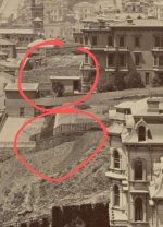
First of all, I have a feeling that we are looking at a roof of a buried building. Then we have this little red arrow I put in there. Is it a wire it is pointing at? If it is a wire,what could it be for?

electricity_1.jpg

Source
I'm wondering who could see this weather vane from the ground? What if it was mounted that high for a different purpose?

Weather Vane
weathervane_SF.jpg


Are those flower bed type thingies?
flower bed.jpg

Source

Atmospheric Electricity?
electricity_2.jpg

Source

Churches and Cathedrals
This one is out of curiosity. How many churches, and cathedrals can you count in this 1878, 30 year old city of San Francisco?

sf_cathedral.jpg


Construction Equipment
This is what they built this city with, I guess...

construction_equipment.jpg


KD: Anyways, I just wanted to see what your opinion on these photographs was. Something is not right about all of this.
  • I'm wondering how much of this 1878 San Francisco did not get into the photo due to being behind the photographer.
  • Also, what do you think about the future expo buildings being possibly buried in the dirt?
  • Where are the people?
  • Where are all horses?
 
On 11 July 1877, Eadweard Muybridge (1830-1904) announced in the San Francisco Bulletin the publication of a “Panorama of San Francisco from California Street Hill.” The photographs were taken from the tower of the Mark Hopkins mansion, then the highest point in San Francisco, 116 metres (381 feet) above the harbour, which commanded an uninterrupted, sweeping view of the entire city, its harbour, and San Francisco Bay. One year later, Muybridge re-photographed the view, as seen here.

View attachment 2512
This San Francisco was destroyed: Who nuked San Francisco in 1906?
KD note: I wanted to get this out of the way real quick. This city is not 100% abandoned. Its population in 1880 was supposed to be 234 thousand people. This high quality image allowed me to spot like may be 50-70 people, and about as many horse buggies. Yet, when you fully comprehend the size of this "30 y.o." city, 234k will sound unreasonable. It was supposed to have at least four times that, IMHO.
  • This city appears to be dead. No chimney smoke, no day to day activity, no nothing... just the void of emptiness.
1878 Panorama of San Francisco
I ran into a website which has a crazy size version of this panchromatic photograph. In my opinion the photographs reveal way too much, and I wanted to offer our blog members to do a thorough investigation of this photograph. This 1878 resolution should probably be illegal.

I think the story of San Francisco is very similar to the one of Saint Petersburg. Points of discussion I would like to offer:
  • This city does not look brand new, and has no signs of any serious construction development.
  • It was impossible to build what you see in the photograph within 30 years, with what they had.
  • California Gold rushers of 1848-1855 were indeed digging for "gold", with gold being the city of San Francisco itself.
    • I think they were digging San Francisco out of the mounds of dirt.
  • Multitude of strange "little things". This photograph has quite a few to offer.
  • Could the buildings of the future 1915 SF Expo be buried underneath some of the hills?
What style of cathedral is that?
or... is it a power station?

View attachment 2511
Source

The history of San Francisco effectively started in 1848. Wikipedia mentions 1776, but this date is irrelevant for our investigation. Here is why.


We are only concerned with the range of 1848 - 1880, because the photograph in question was allegedly made in 1878.

Gold Rush
The California Gold Rush (1848–1855) began on January 24, 1848, when gold was found in Coloma, California. The news of gold brought approximately 300,000 people to California from the rest of the United States and abroad.
  • San Francisco grew from a small settlement of about 200 residents in 1846 to a boomtown of about 36,000 by 1852.
KD: The influx of people was always historically explained by this Gold Rush. In reference to this I have the following questions:
  • If they were digging for gold - who built the city?
  • If they were building the city - who was digging for gold?
1915 Exposition
Below we have two differently dated visual representations of the famous Palace of Fine Arts. It was allegedly built out of horse hair and plaster, aka staff, for the 1915 Panama-Pacific International Exposition. The date of 1915 at first glance appears to have nothing to do with 1878. Yet, if the Expo structures were simply restored using previous architecture, the relationship between 1878 and 1915 could be a bit more obvious.
If this painting is representative of what this complex looked like in 1915, it does put a big dent into the 1915 Expo narrative. Does it look brand new, or temporary?
  • While the Palace had been saved from demolition, its structure was not stable. Originally intended to only stand for the duration of the Exhibition, the colonnade and rotunda were not built of durable materials, and thus framed in wood and then covered with staff, a mixture of plaster and burlap-type fiber. As a result of the construction and vandalism, by the 1950s the simulated ruin was in fact a crumbling ruin.
These photograph (or photographs, if you want to consider individual photos comprising this panoramic) has weird little things, which stand out when you start looking for them. Below we have a few examples. See if you can spot anything interesting, and please share with the rest.

First of all, I have a feeling that we are looking at a roof of a buried building. Then we have this little red arrow I put in there. Is it a wire it is pointing at? If it is a wire,what could it be for?

I'm wondering who could see this weather vane from the ground? What if it was mounted that high for a different purpose?

Weather Vane
View attachment 2517

Are those flower bed type thingies?
View attachment 2510
Source

Atmospheric Electricity?
View attachment 2509
Source

Churches and Cathedrals
This one is out of curiosity. How many churches, and cathedrals can you count in this 1878, 30 year old city of San Francisco?

View attachment 2513

Construction Equipment
This is what they built this city with, I guess...


KD: Anyways, I just wanted to see what your opinion on these photographs was. Something is not right about all of this.
  • I'm wondering how much of this 1878 San Francisco did not get into the photo due to being behind the photographer.
  • Also, what do you think about the future expo buildings being possibly buried in the dirt?
  • Where are the people?
  • Where are all horses?
My point of view about Palace of Fine Arts. I don't think it was built between 1906-1915 for Panama-Pacific Expo. I guess it was built before the global disaster. We don't have a single picture of the process of construction and it's just a bit more than 100 years ago. We have pictures from mid 19th century but no from 20th one which should be obvious. How did it happen that no a single photographer followed the process of that construction? Questions, questions and questions.
 
In most of these photos the windows look like they were boarded-up. I thought they were just drawn shades but they are the same on the side of the building that isn't in the sunlight.

The pictures give me the vibe of an empty city being gradually taken over by newcomers.

Edit: Found a building where someone scribbled 1877 on the roof for no apparent reason. Is that the year when the newcomer claimed the empty building? Why would someone go on the roof and write down the year like that?

1877.jpg

Also, why are there ladders and planks on so many roofs?
 
Last edited:
I ran into this really odd thing:
CAN WE IDENTIFY THESE PEOPLE? (1911) – The Brownstone Detectives
These are random people in a car filmed by a swedish company who has this old film not on their list.

These people are alegged Poles who happend to film there and he turned out to become a (rich??) hairdresser close friends with JP Morgan. Off course.
And he also became member of the Elks.
But he died from a heartattack and got sort of lost.

I am not sure about this, but what if they raided Russians and Poles and Germans and put them on a one way trip to America.
According to Official Wikipedia these people were "helped" by Queen Anne.

There is also a poster with map that they found the best harbour in the world in San Francisco but I can't find it yet.
Edit
I found this and as they note themselve: history is between the pages.
It is a diary of a gold rusher around 1849.

"As much is being said, at this time, about constructing a Railroad from the Atlantic to the Pacific, and thereby connecting five of the most prominent cities of the Union, viz. San Francisco, Salt Lake City, Saint Louis, Akron, and New York."

So basically he said that SF was already a city and still they had to sail by boat and even pay people to do that?

And I don't even know what I am looking at here? Who is that guy in the triangle? (Photo 3)

And look at this, Market street 1877 or is it a really creepy Russian-like parade?

Also do notice that they changed the text on the arch from: e pluribus unum (out of many, one) to the union forever.

And they were selling expensive tents for the gold rush in an already existing city. But it does fit, when a disaster happend and they needed shelter.

And seen on your panorama:
Is this an old fort wall?
Edit 2:

I was just thinking about a poster I saw: "no Chinese allowed"
So: Chinese, Russians (Russian hill) and this sentence:

"and the well-filled sails of vessels, laden with the riches of the Eastern world, were bearing then into our harbor. . . ."

If Tartaria as being Chinese/ Russian this makes sense.

Oh and by the way, they also found tunnels but at the moment I have no time to dig into it, I have to go now.

Screenshot_20210811-093714_1.jpg
 
Last edited:
Also, why are there ladders and planks on so many roofs?
I don't know.

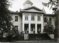
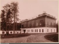
There are plenty of ladder and roof photos from the early 20th century, region of the Vyborgsky District, Leningrad Oblast, Russia, around the old town of Vyborg. Vyborg is located [..]
[..] in the boundary zone between the East Slavic/Russian and Finnish worlds, formerly well known as one of the few medieval towns in Finland, Vyborg has changed hands several times in history, most recently in 1944 when the Soviet Union captured it from Finland during World War II.
Source: Wikipedia on Vyborg

One example photo, please also note the obelisk.

c1arkix54693467dey.jpg

Source: Church in Yaaski, 1930-1940

Two more examples: Manor Kuusa, 1920-1930, Wing of the Nikolaev branch of the Imperial sanatorium "Khalila", 1897-1900.

There are dozens if not more examples to be found in the video "Ancient Tartarian Cities - Vyborg" uploaded by YouTube user Olafthesverker (Link). The presenter of the video is mocking these seemingly omnipresent and conspicuous ladders several times during the course of the video. I just followed the URLs in the banners at the bottom of the images shown.

I would not have found this peculiar, if there were not so many similar photos, without inhabitants or other human beigns depicted, always a ladder, same timeframe, same region.

pheh25k2fheezpmjwb.jpg i8rxlo51b34bmr9t9o.jpg
 
I did find a very small clue about the fair. I think it was already existing but not open to public, because on older maps the area is most of the time "a reservation" or "government site". I Don't think we will find it at the panorama photo because there are too many hills.
But I am not sure if I'm looking at a wall over here?

Screenshot_20210815-153431.jpg

Industrial exhibition in 1857 only 8 years after the gold rush, this is off course a temporary canvas tent, not a building.

1st-fair-building.jpg

"Forgotten" 1894 mechanics exposition:

wnp26.970.jpg

I don't even know what I am looking at: an electric spiral tower? With a mosque?

These middle east/ ? people on that 1894 expo look very... Happy. Almost as happy as the displayed Indians on the later exhibitions.

720px-Cairo_Street_camels_and_drivers_wnp15.141.jpg

And here a 1914 picture of the later added buildings of the Panama expo, I don't think these buildings look very new.

They look very like that first industrial expo:

expo-2.jpg

And by the way I wonder what camels have to do with a mechanic exposition?
 
Please will you take the time to add in the links to the various photographs.
 
Last edited:
What a fascinating image to scour. One of the first things I noticed was the difference in roofing between the brick and mortar buildings and the stick built structures. Chimneys, pitches, shingles, etc… I’m not sure what it means.

then, I was sidetracked by this:

1FDC1568-648E-48F9-8F60-2970A5FDD194.jpeg

can anybody identify this? It’s atop this very interesting spire:

B9078979-6382-4186-86A1-0050AB135F56.jpeg
 
Thanks for all of this. Did you notice all the nappies on the roof top cloths lines? I can only find one adult cloths line, but plenty of nappies, some of which are near your 'power station' 500 babies maybe?
 
Thanks for all of this. Did you notice all the nappies on the roof top cloths lines? I can only find one adult cloths line, but plenty of nappies, some of which are near your 'power station' 500 babies maybe?
I'm not sure I can zoom in close enough to say what these are. Could be nappies, could be bed sheets or table cloths. Unless you are referring to a different segment of the photograph.

sf19th-1.jpg
 
Yeah, they definitely have tons of white stuff drying out in various sections of this panoramic. I struggle make out what those are.

sf56-1.jpg

@reverendALC, this looks like an "H" or "N" depending on where observed from. Hard to say what it is. I wish we knew what building that spire belonged to.

sf-78.jpeg
 
@reverendALC, this looks like an "H" or "N" depending on where observed from. Hard to say what it is. I wish we knew what building that spire belonged to.


My eyes saw a stylized H. I attempted put it through google lens to no avail. I’ll attempt to recreate it in a cleaner format and try again.

I fear it may not be “original” considering the alarming lack of any other markings visible in the photo, aside from what’s been plastered on this rickety fencing:

B015FAA5-EF92-4E18-B335-9B520421C07A.jpeg

Does that say “hammam baths”??
 
I’m not sure if there’s any angle here, but I found a webpage with a list of known historical hammam/Turkish baths:

SAN FRANCISCO, CA: Bush St/Larkin St: Turkish Baths (Men only)
SAN FRANCISCO, CA: Dupont St (11): Turkish & Medical Baths
(Loryea & Trask)
1876, 1880
SAN FRANCISCO, CA: Ellis St (229): Turkish Baths (Men only; latterly
gay)
1911—1980s
SAN FRANCISCO, CA: The Hammam1875—
SAN FRANCISCO, CA: Market St (957): The Empress Turkish Baths1913
SAN FRANCISCO, CA: Mason St (130) Oriental Turkish Baths
(W J Blumberg & Bro)
1905
SAN FRANCISCO, CA: Montgomery St (722): Russian & Turkish Baths
(A Alers)
1876
SAN FRANCISCO, CA: Pacific St (524): Turkish & Russian Baths
(Frederick Zeile)
1876
SAN FRANCISCO, CA: Post St (222): The Post Street Turkish Baths
(A Johnson)
1894, 1912
SAN FRANCISCO, CA: Post St (624): Sultan Turkish Baths1905—1928
SAN FRANCISCO, CA: Union Square: St Francis Hotel Turkish Baths1917—1940
SAN FRANCISCO, CA: Calvin Huyett's Turkish Baths
Destroyed in 'quake
—1906

It may be possible to identify the one advertised and go from there. Arbitrarily choosing the Loryea & Trask entry on DuPont St, I was able to find this interesting webpage with some questionable assertions:

Chinatown’s Grant Avenue: A look back at one of San Francisco’s oldest streets

In 1839 a survey of Yerba Buena (original SF name) was drawn by Jean Vioget, a surveyor and sea captain, including the current layout of Grant Avenue. While credited as the first surveyor of Yerba Buena, he didn’t name any of the streets.

1847_ofarrell_SF_map.jpg

Jasper O’Farrell’s 1847 survey map with added street names. Image via UC Berkeley, Bancroft Library. Calle de la Fundación was renamed Dupont Street in honor of the USS Portsmouth’s admiral.

1839_voiget_map.jpg
 
Admittedly, I have a habit of digression and then laser focus on the minutia. That image is a great panorama of unknown to me, and a “verifiable” anchor point would potentially make it easier to identify other buildings.

I’ll keep any further digression to myself 😬
 

Similar articles

Back
Top