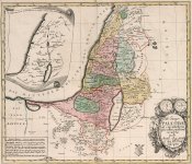
For centuries people knew exactly where Sodom and Gomorrah once stood. The ruins of the Biblical cities were apparently still visible as late as 1650. Only with the approach of the 19th century did we conveniently forget where to look for the famous cities of sin. Their sins we could debate at a later date, but for right now let us point our ever-blind and ignorant archaeologists in the right direction. Before we get into the grid coordinates, let's see what the official version says.

Wikipedia, "There are other stories and historical names which bear a resemblance to the biblical stories of Sodom and Gomorrah. Some possible natural explanations for the events described have been proposed, but no widely accepted or strongly verified sites for the cities have been found. Of the five "cities of the plain", only Bela, modern-day Zoara, is securely identified, and it remained a settlement long after the biblical period." There is a whole bunch of additional worthless information in the wiki article, none of which points to the obvious. It starts to look, and sound like our overzealous archaeologists are working hard at not finding anything on purpose.
We have 5 cities which were allegedly punished by God. According to the Torah, the kingdoms of Sodom and Gomorrah were allied with the cities of Admah, Zeboim, and Bela. These five cities, also known as the "cities of the plain", were situated on the Jordan River plain in the southern region of the land of Canaan.
Divine judgment by God was passed upon Sodom and Gomorrah and two neighboring cities, which were completely consumed by fire and brimstone. Neighboring Bela was the only city to be spared.
KD: I do not believe for a second that there were thousands of years between the destruction of Sodom and Gomorra, and the first of the maps below. If I was to guess the time frame, I'd go with 1,000 AD -1,400 AD on the conventional time scale.


Essentially what we get is the sea with no water. Apparently, it was claimed that the dead Sea was filled with asphalt and Arabs rode their camels to travel across the Dead Sea.
Wiki: These five cities, also known as the "cities of the plain", were situated on the Jordan River plain in the southern region of the land of Canaan.
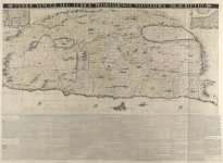
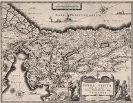
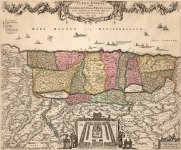
This 1655 map has to be viewed on the source site. It is so detailed, that I am unable to do it justice by pasting cut outs here. It gives as a pretty good idea of where these 4 lost cities once stood.
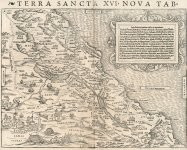
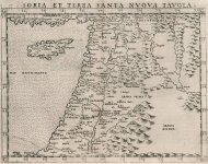
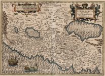
All of the below maps contain the cities which are presumably either lost, or have never existed. There is plenty of additional info within the maps pertaining to the topic of this thread. If you are good with translating things, please contribute.
Source of all the above maps. The link will take you to the search results. Simply pick a year on the left side of the screen and investigate away.

"Likewise as it was in the days of Lot - they ate, they drank, they bought, they sold, they planted, they built, but on the day when Lot went out from Sodom fire and sulphur rained from heaven and destroyed them all - so will it be on the day when the Son of man is revealed."

Forbidden Archaeology: Sodom and Gomorrah - Gentlemen in this article think that they found the lost cities. Well, that I'm not so sure of, but they sure did locate millions of balls of sulphur around the Dead Sea. Allegedly this is like 90% pure sulphur which does not exist in this state in nature. This source is not the only one as far as Dead Sea sulphur goes.
KD: I think that our not-so-lost cities are at the bottom of the today's Dead Sea. Its depth is allegedly 1,000 feet, so I'm not sure how that works. If it used to be a regular dried out salt lake which was covered in asphalt at some point, then where did 300 meters of water come from. May be the entire area got flooded to hide this enormous carnage scene. May be it got flooded because they were unable to destroy everything they wanted to destroy.

Zoar - Bela
was here

Today's MapAs far as I understand, the asphalt lake did not go below the red line back then. If so, why do historians place Zoara so far south?

Looking on the internet for our contemporary related information, produced the following front page of The Sunday Times newspaper. It is dated with 11/21/1999.

There was also this this webpage located by esgee1. The date of The Sunday Times article is listed as 03/26/2000:
Mr. Sanders also stated that they did a documentary for NBC and channel 4 in the UK. I am not sure if the video below (courtesy of esgee1) is the one. Unfortunately no other "bottom of the Dead Sea" related videos could be found.
Evidence Destruction?
I want to finish this article by mentioning a highly suspicious (in my opinion) experiment. Judge for yourself whether the timing of these "scientific" underwater explosions was a mere coincidence, or the PTB was destroying the remnants of Sodom and Gomorrah due to the unwanted research being done.

KD summary: I seriously doubt archaeologists want to find these cities, for (per whitewave) Sodom and Gomorrah have been found. Their modern names are listed with a plausible explanation for the fire raining down from the sky.
Wikipedia, "There are other stories and historical names which bear a resemblance to the biblical stories of Sodom and Gomorrah. Some possible natural explanations for the events described have been proposed, but no widely accepted or strongly verified sites for the cities have been found. Of the five "cities of the plain", only Bela, modern-day Zoara, is securely identified, and it remained a settlement long after the biblical period." There is a whole bunch of additional worthless information in the wiki article, none of which points to the obvious. It starts to look, and sound like our overzealous archaeologists are working hard at not finding anything on purpose.
We have 5 cities which were allegedly punished by God. According to the Torah, the kingdoms of Sodom and Gomorrah were allied with the cities of Admah, Zeboim, and Bela. These five cities, also known as the "cities of the plain", were situated on the Jordan River plain in the southern region of the land of Canaan.
Divine judgment by God was passed upon Sodom and Gomorrah and two neighboring cities, which were completely consumed by fire and brimstone. Neighboring Bela was the only city to be spared.
- Sodom - destroyed
- Gomorrah - destroyed
- Admah aka Adama - destroyed
- Zeboim - destroyed
- Bela - spared
Sodom and Gomorrah
+ neighboring Admah and Zeboim
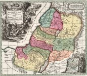
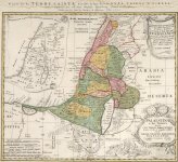
The below presented maps cover years 1540 - 1753. Supposedly these 4 cities were destroyed between 2000 BC and 1900 BC (according the Biblical Timeline). I find it tremendously suspicious that the memory of their exact location made it through 3,750 years of history, including the periods below, but then somehow got lost.+ neighboring Admah and Zeboim
- Bronze Age
- Iron Age
- Ancient History
- Classical Antiquity
- Post-Classical Antiquity
- Middle Ages
- Early Modern Period
KD: I do not believe for a second that there were thousands of years between the destruction of Sodom and Gomorra, and the first of the maps below. If I was to guess the time frame, I'd go with 1,000 AD -1,400 AD on the conventional time scale.
The Maps
We will take a look at a couple of specific map cutouts first. They provide us with some interesting information.1586
Historical map of Israel, Canaan with the Wanderings of Abraham.
Printed around 1595 in Antwerp


Abrahami Patriarchae Peregrinatio Et Vita #1
Abrahami Patriarchae Peregrinatio Et Vita #2
Note: on the above Ortelius map with 1586 contents we can see that the Dead Sea does not exist yet. The river Jordan is flowing freely through "plains" which will eventually become the Dead Sea.Historical map of Israel, Canaan with the Wanderings of Abraham.
Printed around 1595 in Antwerp
Abrahami Patriarchae Peregrinatio Et Vita #1
Abrahami Patriarchae Peregrinatio Et Vita #2
1651
Canaan - Jerusalem

source
1720
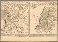
Two maps on one page.
A "modern" 1720 map and an ancient map of the Holy Land.

source
Canaan - Jerusalem
source
1720
Two maps on one page.
A "modern" 1720 map and an ancient map of the Holy Land.
source
- here was Sodom, and its remains could be seen until 1650
- here was Gomorrah
- This sea, which is surrounded by high mountains, is 25 leagues long, and five broad, filled with black bitumen (asphalt) and tips, and its edges covered with a species of talc or niter.
- Arabs crossed the Dead Sea on their Camels.
Essentially what we get is the sea with no water. Apparently, it was claimed that the dead Sea was filled with asphalt and Arabs rode their camels to travel across the Dead Sea.
Wiki: These five cities, also known as the "cities of the plain", were situated on the Jordan River plain in the southern region of the land of Canaan.
- In geography, a plain is a flat, sweeping landmass that generally does not change much in elevation. Plains occur as lowlands along the bottoms of valleys or on the doorsteps of mountains, as coastal plains, and as plateaus or uplands.
This 1655 map has to be viewed on the source site. It is so detailed, that I am unable to do it justice by pasting cut outs here. It gives as a pretty good idea of where these 4 lost cities once stood.
All of the below maps contain the cities which are presumably either lost, or have never existed. There is plenty of additional info within the maps pertaining to the topic of this thread. If you are good with translating things, please contribute.
- The below 10 maps have a good enough resolution to work with.
Source of all the above maps. The link will take you to the search results. Simply pick a year on the left side of the screen and investigate away.
Sulphur Weapons
"Fire and brimstone is an idiomatic expression of referring to God's wrath in the Hebrew Bible. In the Bible, it often appears in reference to the fate of the unfaithful. Brimstone, an archaic term synonymous with sulfur, evokes the acrid odor of sulphur dioxide given off by lightning strikes. Lightning was understood as divine punishment by many ancient religions; the association of sulphur with God's retribution is common in the Bible." - Wikipedia
KD: I think that our not-so-lost cities are at the bottom of the today's Dead Sea. Its depth is allegedly 1,000 feet, so I'm not sure how that works. If it used to be a regular dried out salt lake which was covered in asphalt at some point, then where did 300 meters of water come from. May be the entire area got flooded to hide this enormous carnage scene. May be it got flooded because they were unable to destroy everything they wanted to destroy.
- Or may be because these cities were situated in the land of Canaan. Cynocephali people, including Cynocephalus Saint Christopher were Canaanite.
- Some food for thought: ...in reference to a possible connection there > Canine - Canaan - Canaanite
Zoar - Bela
was here
Today's Map
Looking on the internet for our contemporary related information, produced the following front page of The Sunday Times newspaper. It is dated with 11/21/1999.
There was also this this webpage located by esgee1. The date of The Sunday Times article is listed as 03/26/2000:
In October of 2018 I contacted Michael Sanders to follow up on the fate of the expedition. He replied that they did not have the resources to take another submarine down. He also stated that he was too old to follow up. Mr. Sanders mentioned a graduate student who was a part of the project at the time. Supposedly, that student wrote a PhD thesis including the expedition. There was no student name provided, so if you run into the mentioned PhD thesis, please share the goods.A Bible scholar believes that he has found the ruins of Sodom and Gomorrah, the evil cities destroyed by God with fire and brimstone, after leading the first expedition to explore the bottom of the Dead Sea.
Michael Sanders [a long-time CCNet-subscriber] and an international team of researchers discovered what appear to be the salt-encrusted remains of ancient settlements on the seabed after several fraught weeks diving in a mini submarine. Mr. Sanders, a Briton who is now based in the United States, said yesterday that he was "immensely excited" about the find, and he is already planning a follow-up expedition.
He said: "The evidence cannot be ignored. I predicted there must be something extraordinary there and, lo and behold, there was. What we found matches exactly what the remains of an ancient city might look like."
Dr. John Whitaker, a geologist from Leicester University and the former editor of Geology Today, said yesterday that the new development - which will be unveiled in a television documentary tomorrow - appeared "very significant". He said: "There is a good chance that these mounds are covering up brick structures and are one of the lost cities of the plains, possibly even Sodom or Gomorrah, though I would have to examine the evidence. These Bible stories were handed down by word of mouth from generation to generation before they were written down, and there seems to be a great deal in this one."
God's destruction of Sodom and Gomorrah to punish the sexual immorality of their inhabitants is one of the most graphic episodes in the Old Testament. Genesis says that "the Lord rained upon Sodom and upon Gomorrah brimstone and fire out of heaven. And he overthrew those cities, and all the plain, and all the inhabitants of the cities, and that which grew upon the ground".
Many archaeologists and scholars have concluded that the story was symbolic, a warning to erring humans of the divine punishment they faced for wickedness. But there has been speculation for centuries that the cities existed in the region of the Dead Sea. A growing number of experts, including Mr Sanders, are now convinced that "the cities of the plain" were destroyed by an earthquake, which threw up flaming pitch, about 5,000 years ago.
Since the 1960s, archaeologists have discovered mass graves on a peninsula jutting into the Dead Sea which contain human bones dating from the Old Testament period. And sulphur, or brimstone, have been found in nearby cliffs, adding to the mystery.
More recently, Mr. Sanders unearthed a map dating from 1650 which reinforced to his belief that the sites of the two cities could be under the north basin, rather than on the southern edge of the Dead Sea. He recruited Richard Slater, an American geologist and expert in deep sea diving, to take him to the depths of the Dead Sea in the two-man Delta mini-submarine that was involved in the discovery of the sunken liner, the Lusitani.
Also part of the expedition, which took place in November, was Zvi Ben-Avraham, the director of the Dead Sea Research Centre, who has studied the region for decades. Their explorations in November, which were filmed for a Channel 4 documentary to be broadcast at 8pm tomorrow night, were fraught with difficulties. The 10ft submarine, which was
flown in from California, had to be weighted down with lead to counteract the buoyancy of the salty water. Because of constraints of time and money, only four dives were undertaken.
To complicate matters further, the Dead Sea is a military zone with the border between Israel and Jordan running down the middle of it. Attempts by researchers to explore the most important site nearly sparked an international incident because it was partly in Jordanian waters, and military authorities ordered the submarine out.
Mr. Sanders is in little doubt that the salt-covered mounds, found over an area 800 yards square, are man-made structures. He said: "I have spoken to geologists and nobody has come up with the suggestion that they are natural phenomena. We don't know what else they could be if they are not ruins. But we need more conclusive evidence by chipping off the salt. That's why we need to go back."
Mr. Sanders also stated that they did a documentary for NBC and channel 4 in the UK. I am not sure if the video below (courtesy of esgee1) is the one. Unfortunately no other "bottom of the Dead Sea" related videos could be found.
Evidence Destruction?
I want to finish this article by mentioning a highly suspicious (in my opinion) experiment. Judge for yourself whether the timing of these "scientific" underwater explosions was a mere coincidence, or the PTB was destroying the remnants of Sodom and Gomorrah due to the unwanted research being done.
- Three large-scale underwater chemical explosions were conducted on November 8-11, 1999 in the Dead Sea. The main objective of the experiment was calibration of seismic stations in the Middle East that provide monitoring of underground nuclear tests, using accurate travel times of seismic waves. The largest shot produced a seismic magnitude of about 4, and was recorded at distances up to 3500 km.
- Blast Wave Observations for Large-Scale Underwater Explosions in the Dead Sea
- Three chemical charges of 500, 2060 and 5000 kg were detonated in November, 1999 in the Dead Sea
- Near-source audiovisual, hydroacoustic, and seismic observations of Dead Sea underwater explosions
KD summary: I seriously doubt archaeologists want to find these cities, for (per whitewave) Sodom and Gomorrah have been found. Their modern names are listed with a plausible explanation for the fire raining down from the sky.
- IMHO, the PTB know exactly where Sodom, Gomorrah, Admah and Zeboim once stood. Whether it's ancient tech they are hiding, or the remains of the hybrid people, but the true Rulers will never allow for them to be discovered.
Yup, multiple governments should definitely be concerned that the Dead Sea is dying, for... what's at the bottom?It all hints at a problem that has vexed multiple governments and sparked concerns among researchers, environmentalists and anyone else with an interest in this iconic salt lake, which is woven into the history of Islam, Christianity and Judaism.


